
“How big is the lawn actually?”
Maintenance services are tendered and billed by area. If the figures come from old plans or estimates, you pay too much – or the service provider loses out.
Capture green spaces, paths, winter service areas, trees and manholes to the centimetre – with photo and location. For maintenance contracts, duty of care and your as-built records in CAD, GIS and CAFM.

Maintenance, winter service and duty of care depend on areas that often nobody knows exactly. That costs money in every tender – and certainty when damage occurs.
Maintenance services are tendered and billed by area. If the figures come from old plans or estimates, you pay too much – or the service provider loses out.
Who clears where, with which priority? An overview of all areas requiring winter service is the first step of any winter service plan.
For a refurbishment, fibre installation or a new playground, the position of lines and manholes is missing – and the excavator goes searching.
of the German Civil Code (BGB) is the basis of the duty of care for outdoor areas. If you document inspections properly, you are in a better position when damage occurs – and that starts with an overview of areas, trees and play equipment.
Note, not legal adviceCreate the property, walk the site, records in the cloud – for management, service providers and planners.
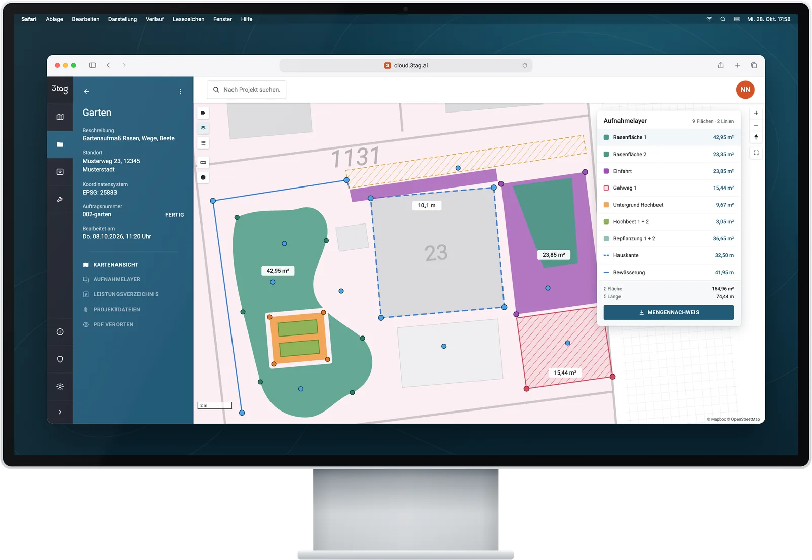
Create the property, load a site plan or georeference it as a PDF, create layers for green spaces, paths and winter service.
Example: Residential complex Musterweg, three buildings, site plan as PDF
Walk around areas, set trees, manholes and play equipment as points, record damage with photos.
Example: Lawn 154.96 m², tree 07 with photo, manhole S3
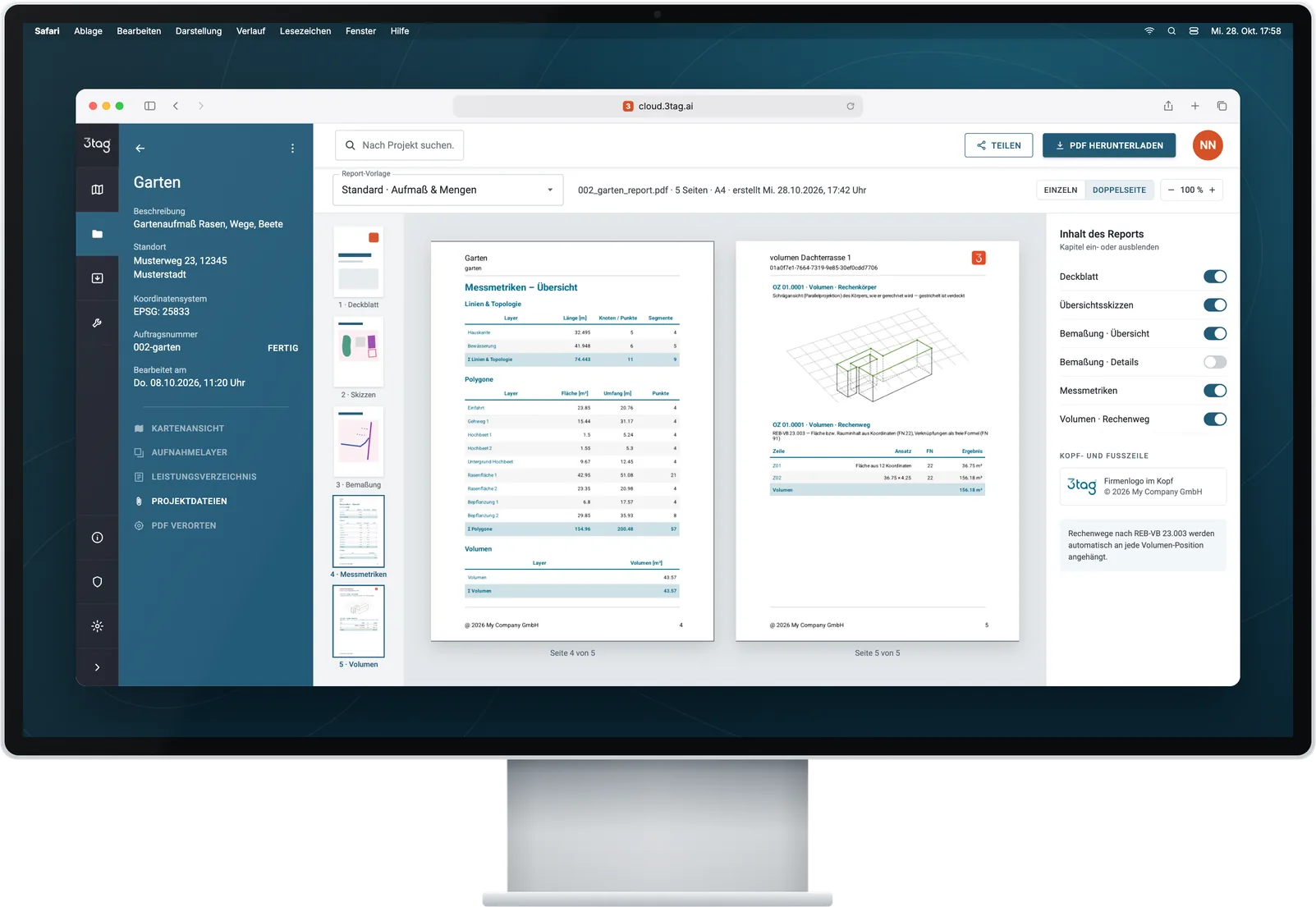
Area register as PDF report, geometries as DXF – with Premium, full GIS and CAD.
Example: Area list for the landscape maintenance tender
Walk it once – and you have an area register you can trust. For maintenance contracts, tenders, winter service plans and the next refurbishment.
| Lawns and maintained areas | 1,240 m² |
|---|---|
| Paths and paving | 860 m² |
| Winter service priority 1 | 420 m |
| Trees | 9 |
| Manholes | 4 |
| Playground | 1 |
PDF reportDXFCSVPremium and up: DWG · Shape · GeoPackage
For property managers, housing companies, caretaker and facility services – with the packages marked.
Capture lawns, beds, hedges, paths and car parks – as the basis for maintenance contracts and tenders.
m²PDF reportDXF
Capture paths and entrances that must be cleared, with priority, and hand them to the service provider as a plan.
LinesAreasPlan
Set objects as points with photo and attributes – the basis for recurring inspections.
PointsPhotos
Survey house connections and lines while the trench is open – for the next construction project.
PositionDepthPhotos
Document root heave, trip hazards and subsidence with photo and location and commission the repair.
PhotosPDF report
Pass on geometries and attributes as DWG, Shape or GeoPackage. Tailoring to your CAFM system is part of Enterprise.
DWGShapeGeoPackage
All packages use the same 3tag device with the same accuracy. Custom export formats and integrations are part of Enterprise.
Outdoor and maintenance areas go into the programs you use to manage and plan properties.
For CAFM systems, we align data and import rules with your process (Enterprise).
For as-built maps, outdoor areas and area registers (Premium and up).
Plans for refurbishment, maintenance and winter service – as a CAD file or PDF report.
Software examples with documented import paths. The software version, licence and import configuration determine what is available.
If you want to use old site plans, pass data to GIS, CAD or CAFM and work as a team, Premium is the right choice. For single properties Standard is enough, for large portfolios there is Enterprise.
For caretaker and property services and managers with individual properties.
One-off, incl. hardware and 12 months of software · then €99 per month, billed annually
Areas, points, photos and PDF report – for the area register of one property.
For property managers and facility services that georeference site plans and deliver data to GIS, CAD and CAFM.
One-off, incl. hardware and 24 months of software · then terms in your personal quote
Georeference old PDF site plans, ALKIS and aerial images, DWG and Shape – for up to 5 users.
For housing companies and FM service providers with many properties.
From 3 devices · volume pricing · term contract with service level
Multiple devices, SSO, custom export formats, API integration on request.
Upgrade guaranteeStart with Standard and switch to Premium for €3.500 within the first 12 months – in total no more than buying Premium directly.
All prices plus VAT and shipping · Business customers only · Current offers and volume pricing on request. Compare all features
Areas, photos and records are stored in a German cloud infrastructure. Controlled access and backups protect your property data.
Cloud infrastructure in Upper Franconia.
Personal data processed in line with GDPR.
Encrypted transfer, permissions per project – with Enterprise, mandatory two-factor authentication and SSO.
Backups protect the data against loss.
Your question is not listed? Call us on +49 30 692098611 or write to hello@3tag.ai.
No. After a briefing, caretakers and property staff handle everyday capturing on their own. There are video tutorials for every feature, and with Premium also a live onboarding.
Yes. You import plans as DWG, DXF, GML, KML/KMZ, GeoPackage or Shapefile directly. From Premium, you georeference PDF plans – with ALKIS and aerial images as a basis if you like.
For CAFM systems such as Planon or VertiGIS FM, we align data and import rules with your process. Custom export formats and API integration are part of Enterprise.
No. Boundary and building surveys remain the job of surveying offices. 3tag is made for daily capturing and documentation within your own team.
In a German cloud infrastructure in Upper Franconia – with encrypted transfer, rights per project and regular backups.
In a video call, we go through a site from your portfolio – from the site plan to the area register.
We show 3tag on a property from your portfolio.
We recommend the right package for you – Standard, Premium or Enterprise.
Device, smartphone and logins are delivered to you. The smartphone is included in every package.