
“Tape measure, sketch, overtime in the office.”
Areas are measured by two people, sketched on paper and recalculated in the evening. Every follow-up question means a call to the site.
Measure areas, edges and heights to the centimetre, set out paths and beds, assign quantities directly to the BoQ item. No folding rule, no notepad, no second person.

Paving, lawn, topsoil: the work outside is running. Measuring it up eats the time you need for the next site.
Areas are measured by two people, sketched on paper and recalculated in the evening. Every follow-up question means a call to the site.
Topsoil, gravel, excavation: volumes are estimated – and in the end the client gets no proof.
Transferring paths, paving edges and planting points from the plan to the ground? Without a surveyor that means string, pegs and hope.
of the skilled worker gap in horticulture falls on landscaping – more than one in four open skilled positions cannot be filled. Every hour not spent on measuring counts.
Source: KOFA Kompakt 06/2026, IW KölnPrepare in the office, measure outside, bill in the office – with the same data and no media breaks.
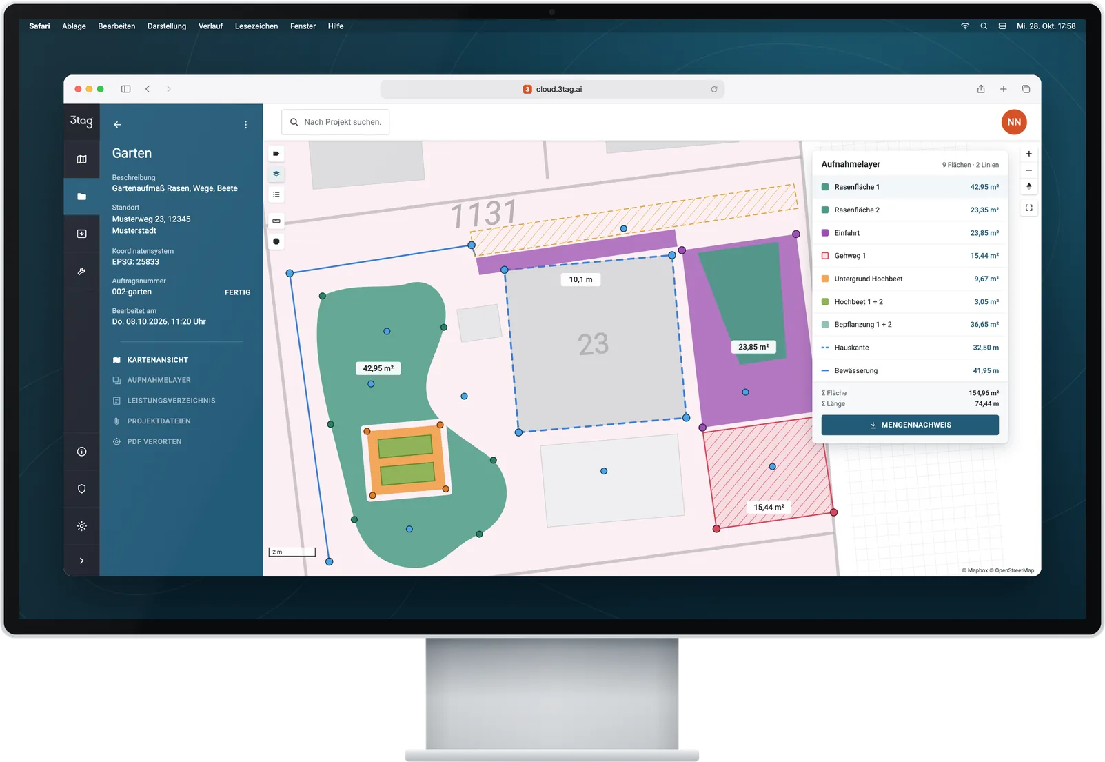
Create a project, load a plan or georeference it as a PDF, import the BoQ from GaLaOffice or GAEB.
Example: Garden at Musterweg 23, BoQ with paving, lawn and planting items
Walk areas and edges, take heights with the laser, set out planting points and path axes.
Example: Paved area 130.81 m², perimeter 47.62 m
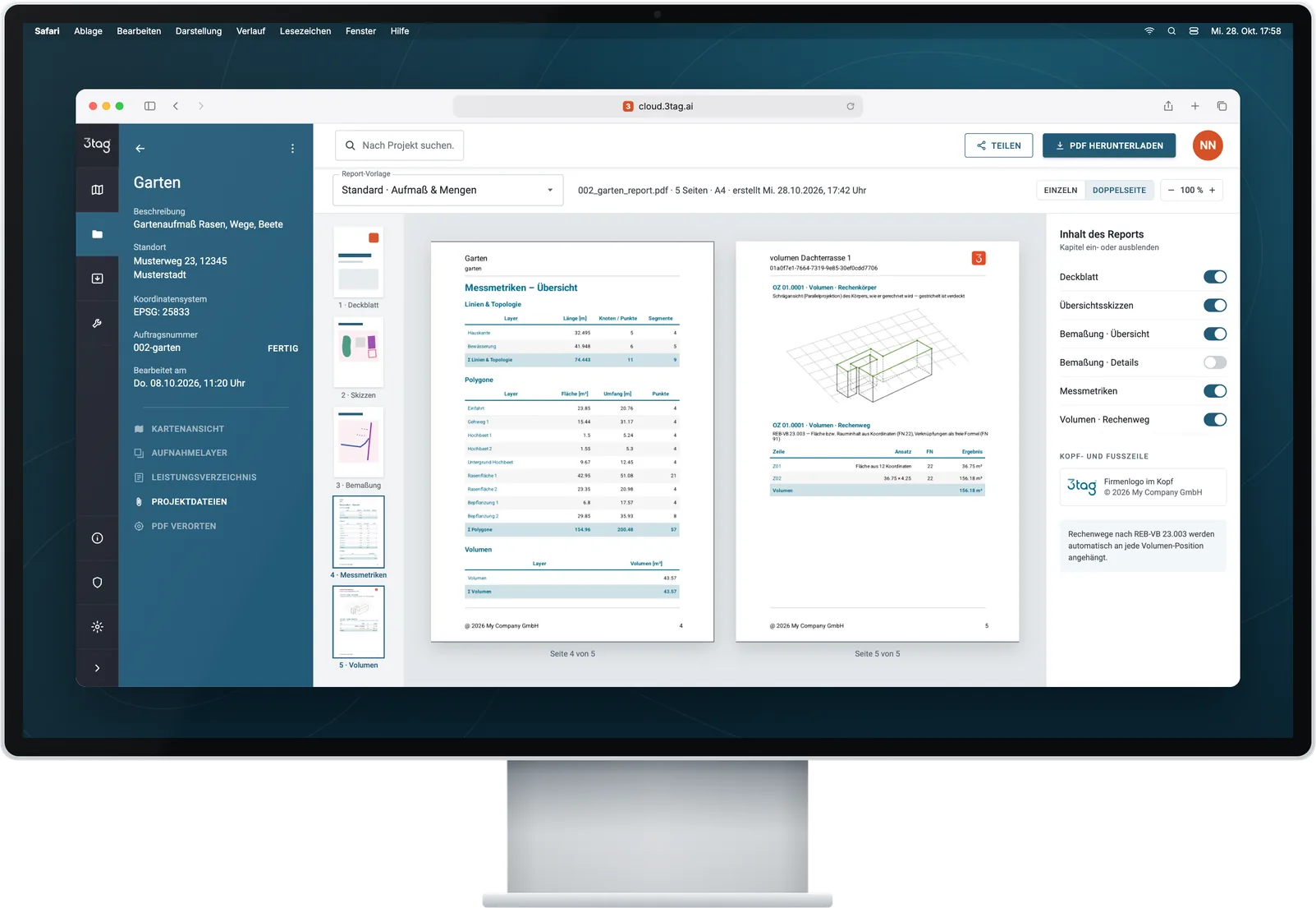
Assign quantities to BoQ items, export a PDF report with photos and REB statement.
Example: REB DA11 to KS21 GaLaOffice 360°
In landscaping, measuring up has been the biggest frustration for years. With 3tag it is done before the crew leaves the site.
Invoice: days later. Proof: a note with a coffee stain.
Invoice: from the office as soon as the data is in. Proof: PDF with photo and sketch.
BoQ assignment and REB/X31 export are included from Premium. Standard delivers PDF report, DXF and point list.
What 3tag handles in everyday landscaping – marked to show what is included in Standard and what comes with Premium.
Walk paving, lawns, beds and paths – area and perimeter are known instantly.
m²PerimeterPhotos
Determine volumes by camera or terrain model, with fixed or variable heights.
m³DTMREB
Find and mark planned positions from the plan on the ground.
Setting outCheck
Import items, link them to the measurement layers and hand them over as REB DA11 or X31.
GaLaOfficeGAEBREB
Capture lawn, hedge and bed areas once and use them for maintenance quotes.
m²PDF report
Document the initial situation and the finished work with photo and location – for acceptance and queries.
PhotosPDF report
All packages use the same 3tag device with the same accuracy. The packages differ in features, users and service.
3tag hands quantities and geometries to the programs landscaping firms use for costing, planning and billing.
Hand over quantities via REB or X31 – depending on the target system (Premium and up).
Measured existing features and areas for the design.
PDF report with sketch, photos and quantities – for the client and acceptance.
Software examples with documented import paths. The software version, licence and import configuration determine what is available.
For maintenance firms and small teams, Standard is enough. If you bill against a BoQ and need volumes, choose Premium.
For small landscaping firms, maintenance businesses and sole traders.
One-off, incl. hardware and 12 months of software · then €99 per month, billed annually
Measure, set out, document – instead of tape measure and notepad.
For firms that bill against a BoQ and work with several people.
One-off, incl. hardware and 24 months of software · then terms in your personal quote
BoQ from GaLaOffice, volumes and REB – the measurement becomes the invoice.
For large firms with several crews and locations.
From 3 devices · volume pricing · term contract with service level
From 3 devices, with service level and rollout.
Upgrade guaranteeStart with Standard and switch to Premium for €3.500 within the first 12 months – in total no more than buying Premium directly.
All prices plus VAT and shipping · Business customers only · Current offers and volume pricing on request. Compare all features
No surveying degree, no tripod, no second person: 3tag fits in your jacket pocket and into the everyday work of a landscaping firm.
The trade magazine for landscaping has reported on 3tag.
Video tutorials for every feature, plus 2 hours of live onboarding on your tasks with Premium.
A full working day on site – the device weighs 580 g.
Cloud in Upper Franconia, GDPR, encrypted transfer, regular backups.
Your question is not listed? Call us on +49 30 692098611 or write to hello@3tag.ai.
No. After a briefing, your team handles everyday measuring tasks on its own. There are video tutorials for every new feature, and with Premium also a two-hour live onboarding based on your use cases.
Yes. From Premium, you import bills of quantities from GAEB and GaLaOffice, link them to the measurement layers and return the quantities as REB DA11 or X31.
GNSS needs as clear a view of the sky as possible. Under dense tree canopies the accuracy can drop – this applies to every satellite-based system. For individual points, camera measurement (AR) helps.
That is what Standard is for. And if you later want to bill against a BoQ, you switch to Premium for €3.500 within the first 12 months – in total no more expensive than buying Premium directly.
In a German cloud infrastructure in Upper Franconia – with encrypted transfer, access rights per project and regular backups.
In a video call, we show you 3tag on a site from your everyday work – from the BoQ to the quantity statement.
We show 3tag on a garden or outdoor area from your everyday work.
We recommend the right package for you – Standard, Premium or Enterprise.
Device, smartphone and logins are delivered to you. The smartphone is included in every package.